Exporting NOTAMs
Warnng!
It looks complicated!
Why can't I see the NOTAMS on my SeeYou map?
NOTAM selection
Airspace selection
NOTAM selection
Why is the 'Export NOTAMs' button disabled?
What is being exported?
Standard OpenAir format
OpenAir format for XCSoar
OpenAir format for LK8000
TNP format for SeeYou
FAF format for Flytec/Brauniger
Warning!
The usual reminder must be restated here : There is no guarantee whatsoever that the data contained in any extracted file is correct. You must check this against the original source at http://www.nats-uk.ead-it.com/public/index.php.html Also, please note that NOTAMS are only up-to-date on the day applicable. You can, of course, extract a NOTAM file days ahead to help with planning a flight, but you will miss any NOTAMs produced later.
It looks complicated!
Yes, it is a bit! The first time you export the NOTAMs, there is a lot to decide. The good news is that once you've done it the first time, the web site will remember your choices. So next time , all those boxes will already be filled in for you. So the next extraction will just be a matter of choosing the date(s) and times, and clicking the 'Export' button.
NOTAM selection.
You can export NOTAMs and/or airspace files for use on navigation instruments. Depeniding on your type of flying, you might want to exclde all sorts of NOTAMs that are not of interest.
If, for example, you don;t intend flying above 5000 feet, then you can exclude all NOTAMs above FL50, or 5,000 feet.
The controls:
- Export navigation warnings
- Export en-route NOTAMs
- Export aerodrome NOTAMs
- Export IFR-only NOTAMs
- Export hidden NOTAMs
- Export NOTAMs for local area only
The first three choices are straight-forward enough. If you want NOTAMs at all, you'll be wanting to tick the Navigation warnings box, and probably the En-Route box too. If you're not flying to or fram an aerodrome, though, you may not want ot see the (very many) aerodrome NOTAMs. If you're flying VFR, the IFR-only NOTAMS may not be usefuil.
Donors to this site have the facility to 'hide' NOITAMs, from the map pages. Unless you tick the 'Export Hidden NOTAMs' box, these hiddden NOTAMs will not be stored on the file.
Finally , the 'Export NOTAMs for local area only' box looks t the local area that uyou have definied on your personal area map, and omnly expoerts NOTAMs fro that aea.
Given the very large capacity pf modern flight instrumtes ,it's probably fine ot get NOTAMs for the entre icountry, anyway.
Next, come the comtrols to control what you don't want exported:
- :
- Captive balloon flights
- Checklists
- Deactivation of danger areas
- Fireworks
- Free balloon ascents
- Kite flying
- Lasers
- Model aircraft flying
- Obstacles
- Overflying Restrictions
- Over 999 NMs radius
Ticking each box determines that NOTAMs with the appropriate code for these activities do not get into the exported file.
Overflying restriction NOTAMs tend to be very large, extending ove the entire FIR, and are not ussually appicable to any flight ove ryour home country.
The final exclusion is by size. You can excude any FIR-wide NOTAM by setting the maximum radious that you allow. Unless you do this, you are likely to find yourself inside the 'airspace' defined by your NOTAMs, and may get visible/audible warnings during the flight. If your instrument allows it, you may elect to read all NOTAMs, and then dismiss those that are too big, or of no concern.
Airspace selection.
To include airspace on your exprted file, tick the 'Export airspace' tick box. The airspace will be appended to the NOTAM file.
You may wish to leave some airspace off:
- Areas of Intense Aerial Activity
- Bird sanctuaries
- Gas Venting sites
- Gliding areas
- HIRTAs
- Obstacles
- NOTAM-activated airspace
- Offshore airspace
- Lasers
- Military training areas
- Radio transmission masts
NOTAM filters and file format specification
First off, you can filter which
Export NOTAMs active between [day] [time] and [day] [time]
Details from surface to [Flight level]
Selecting any flight leve lbelow
Create file of type
Set NOTAMs to class
Set airspace name to be + +
plus + +
Why is the 'Export NOTAMs' button disabled?
Sorry, this facility is for donors only. To use this page, the site needs you to be logged in, and to have made a donation. Of the several thousand pilots who use this site, there are a few kind souls who've paid for the rest of you. They're getting some goodies as a thank you for their donations.
Why can't I see the NOTAMS on my SeeYou map?
SeeYou will display these NOTAMs as 'other' airspace. The default colours for 'other' airspace are not easily visible. Go to 'tools/airspace', and set brighter colours for 'other' airspace.
What is being exported?
The export routine exports NOTAMs in a form suitable for displaying them as airspaces on various flight instruments.
The routine can create files in three different file formats:
- OpenAir
- Tim Newport-Peace
- Flytec Airspace File
All of these are plain text files, and you can edit them, if you want to, using any plain text editor.
There are 5 separate targets for these files:
- Any program/device capable of reading OpenAir or TNP formats
- SeeYou/Oudie
- XCSoar
- LK8000
- Flytec and Brauniger instruments
The devices reading these files do not expect NOTAMs to appear at all on airspace files. How they deal with them when they get them varies wildly. The export routine allows you to be very flexible in the classing and naming of each 'airspace' created for a NOTAM.
You can put the NOTAMs nto the following classes:
- Class A
- Class B
- Class C
- Class D
- Class E
- Class F
- Class G
- Danger area
- Prohibited area
- Restricted area
- Glider-prohibited
- 'Other' airspace
- NOTAM
- NOTAM plus reference
Most should be self-explanatory. The 'glider-prohibited' is usually used for parks and reserves on airspace files. The 'NOTAM' class is the word 'NOTAM' as the airspace class. You can also add the reference, so that you might get :
'AN NOTAM H1234/15' for instance.
Your instrument may not recognise some airspace classes, and may lump them together as 'other' or 'unknown' airspace. The original specification for the OpenAir format does not include classes E,F and G, for instance.
When the NOTAMed airspace is encountered, you will naturally want to see what it is. This is where the name of the airspace comes in. The export routine will allow you to use up to nine elements of the NOTAM for its name. How the instrument processes this varies somewhat. XCSoar, for example, is happy to take the entire NOTAM, and display its contents. Other software, eg the Flytec format, will only accept 16 characters. The nine elements of the NOTAM available are:
- The literal 'NOTAM'
- The NOTAM reference
- The full NOTAM type
- A shorter NOTAM type restricted to 40 characters
- A yet shorter NOTAM type restricted to 25 characters
- The shortest NOTAM type, restricted to 16 characters
- The NOTAM start and end times
- The NOTAM schedule
- The NOTAM text
There is also 'nothing' as a null value, meaning 'do not insert anything more'. The NOTAM type is rather long (possibly up to 96 characters) for most displays, so you may choose the shorter versions that have fewer characters.
Standard OpenAir format
This format is very similar to that produced by the SPINE program by Jeff Goodenough. By default, all NOTAMs are exported as Class F airspace. Of course, genuine Class F airspace is not unknown, but it's relatively rare. We use Class F because the OpenAir format is somewhat limited as to what it will accept.
For example, here is a 'Danger area activated' NOTAM:
AC F
AN F0463/15 DANGER
AL SFC
AH 22000ALT
DP 50:12:44 N 004:46:59 W
DP 50:07:26 N 004:42:28 W
DP 50:00:00 N 004:54:30 W
DP 50:09:24 N 004:54:30 W
The first line is 'AC F' ,and says that this is class F airspace. Line 2 is the name of the 'airspace', in this case the NOTAM reference, and the NOTAM type, much shortened to fit on flight instrument displays. The AL and 'AH: liens display the lower and upper limits of the NOTAM. There folows the description of the airspace, as a series of latitude/longitude locations.
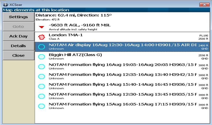
OpenAir format for XCSoar
Here's an example of a NOTAM exported to XCSoar:
AC NOTAM
AN NOTAM Air display 16Aug 12:30-16Aug 14:00 H3901/15 AIR DISPLAY/AEROBATICS WI 2NM RADIUS 511918N 0000431E (VCY BIGGIN HILL, KENT). OPS CTC 07803 713470. 15-08-0337/AS4.
AL SFC
AH 2400ALT
V X=51:19:18 N 000:04:31 E
DC 2
*
Note that the entire NOTAM text is passed to XCSoar. XCSoar will look at the type (here, the type is 'NOTAM'), not recognise it as a standard airspace type, and file it under ''unknown' airspace. So if you click on the airspace above, you will see' 'unknown NOTAM Air display 16Aug 12:30-16Aug 14:00 H3901/15 AIR DISPL... :
Obviously ,ther is not enough room on the display to show all of the text. However, if you select the NOTAM, XCSoar will show the following screen:
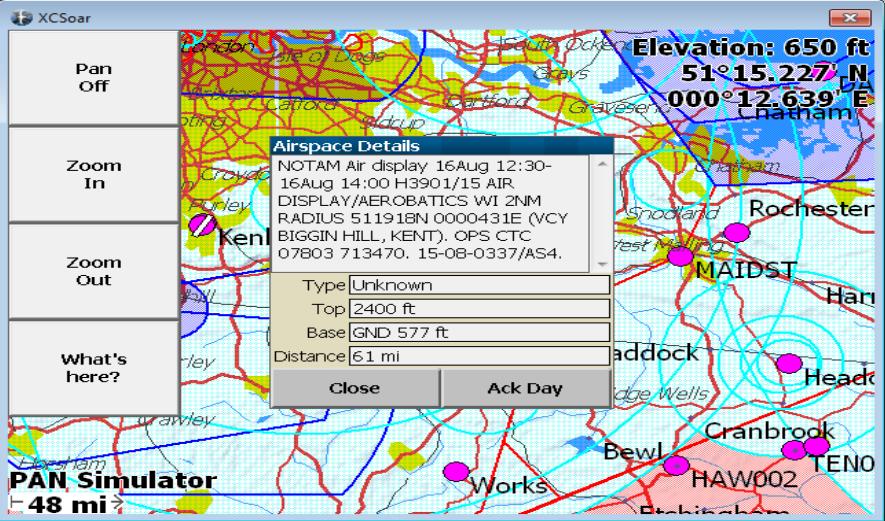
..where you can see the NOTAM i its entirety: The start and end dates/times, the schedule, the NOTAM reference, and the text of the NOTAM in full.
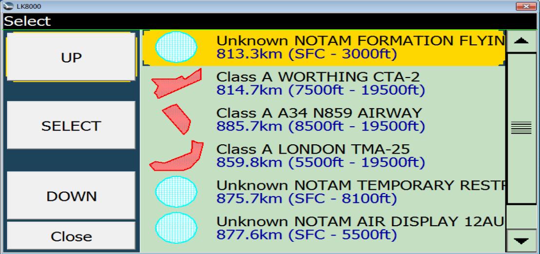
OpenAir format for LK8000
Being an offshoot of XCSoar, LK8000 will accept the same file as XCSaor, with one difference - it cannot cope with very long lines. So the full NOTAM text cannot be exported. Otherwise the file is the same.
Below is a screen shot of the LK8000 screen with the list of airspaces at a location :
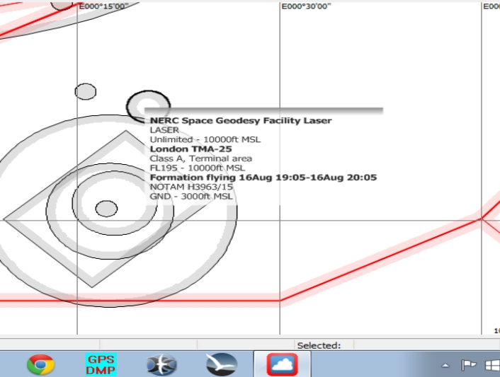
TNP format for SeeYou
TYPE=NOTAM H3963/15
TITLE=Formation flying 16Aug 19:05-16Aug 20:05
CLASS=X
BASE=SFC
TOPS=3000ALT
CIRCLE RADIUS=68 CENTRE=N511951 E0000157
SeeYou will show the airspace type as 'NOTAM H2072/15', and group it with the 'other' airspace. Ensure that you have set the colours up for 'other' airspace, otherwise the NOTAMs might not be visible.
Flytec Airspace File(FAF) format for Flytec/Brauniger devices
The default setting for the flytec file is that NOTAMs are marked as restricted airspace, and the 'name' of the NOTAM airspace consistes of the word 'NOTAM' plus the meaning from the Q record. eg:
AC R
AT
AD
AN NOTAM Captive ba_02
AL SFC
AH 1000ALT
AR1
WD 140
CO
V D=+
V X=50:49.000 N 003:22.000 W
DB 51:48.940 N 003:22.000 W , 51:48.940 N 003:22.000 W
The FAF format has the restriction that the name of an airspace item cannot be more than 16 characters long. Names must also be unique. So any name that is not unique across the first 16 characters will have a number appended to it, to force uniqueness. In the example above, the NOTAM is the second one with the name 'NOTAM Captive Balloon', and has thus been shortened to 'NOTAM Captive Ba' ,and had the number '02' added, to keep it unique.